WEATHER: Tropical Storm Idalia Moves Away From NC Coast
WEATHER ALERT: Tropical Storm Idalia Moves Away From NC Coast

Source: Anadolu Agency / Getty
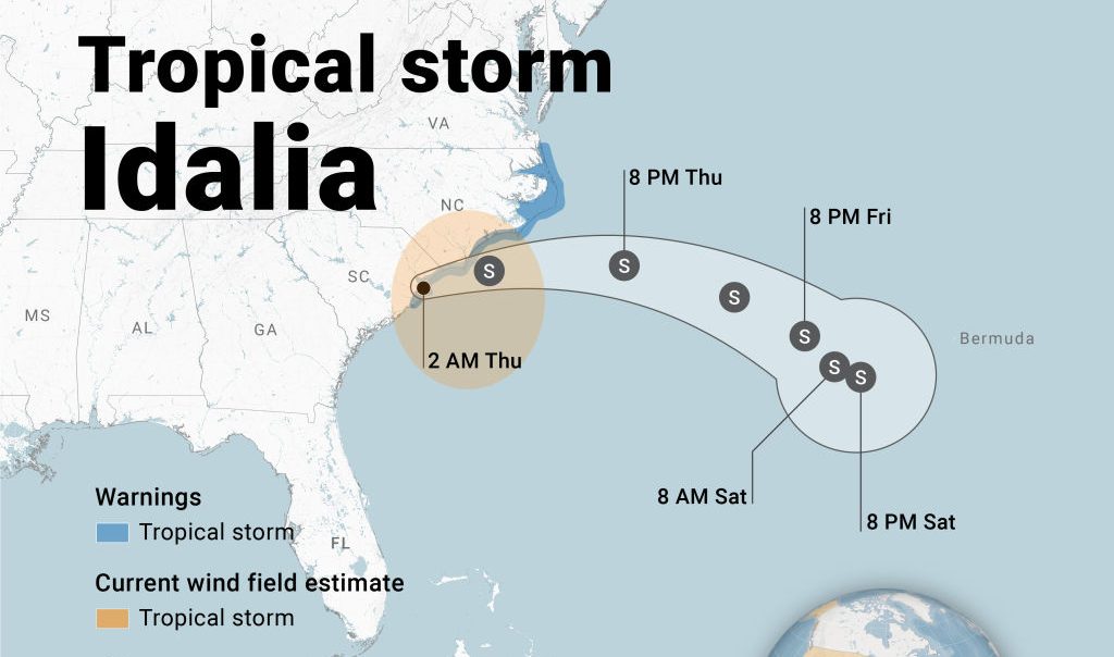
As Tropical Storm Idalia moves away from the North Carolina coast, we take a look at our current conditions and what that could mean for our Labor Day weekend.
Weather Conditions
WRAL reports that conditions were improving at 8 AM as the storm moved farther offshore from the Triangle. At 9 AM, most of the rain was falling east of Interstate 95. It is expected that the rain will move on completely by lunchtime, according to WRAL meteorologist Anthony Baglione.
WRAL meteorologist Elizabeth Gardner added that we could expect fall-like weather on Thursday (Aug. 31), with wind gusts up to 25 mph and possible highs below the 70s.
Get Breaking News & Exclusive Contest in Your Inbox:
Power Outages & Damage
Outside of the Triangle, Idalia did bring some damage. WRAL reported that there were two tornadoes Wednesday night in Brunswick County, near the coast. The coast also saw a storm surge and flooding, as did Fayetteville, southeast of the Triangle.
We are seeing significant power outages along NC’s east coast. Currently, Duke Energy is reporting that over 18,000 customers are without power. The majority of the outages are along the east coast, traveling from the New Bern area down to South Carolina.
Looking Towards Labor Day Weekend
WRAL reports that rain from Idalia should wrap up Thursday, and weather conditions will improve. Raleigh can expect highs in the low 80s on Friday and Saturday. It will be a bit warmer on Sunday and Monday, with temps reaching between the upper 80s and low 90s.
Although it will be near-perfect beach weather, it’s a good idea to stay out of the ocean. Unfortunately, dangerous rip currents will pose a significant threat in the aftermath of both Idalia and Hurricane Franklin.